

Europe
Beyond the French Alps
Gallery: Snapshots of the Alps (Clockwise from top): Piccolo Mangart couloir, Slovenia/Italy (photo: Marco Battistutta); The imposing but serene beauty of the Dolomites, South Tyrol, Italy (photo: Getty Images); the iconic Matterhorn, bathed in moonlight, looming above the fairy-tale-like village of Zermatt, Switzerland (photo: Getty Images); Jungfraujoch Railway, Grindelwald, Switzerland (Getty Images); Canale Joel, Sella Massif, Canazei, Italy (Unsplash); Mont Blanc Massif (Unsplash). Click on images to enlarge.
⎪EUROPE: Beyond the French Alps
Italy, Switzerland, Austria, Germany, Norway, Slovenia, Spain
The alps are the highest and most extensive mountain range on the European continent. Alpinism (a.k.a. mountaineering) has a long history here, highlighted by the first ascent of Mont Blanc in 1786, the Matterhorn in 1865, the Petit Dru in 1935, and finally the last and perhaps most challenging of the Great North Faces, both the Eiger and the Grandes Jorasses in the same year in 1938. Though recreational skiing has its origins in Scandinavia, the world’s first ski lift was installed in Davos, Switzerland in1934. Since then, the alps have become a favorite winter sports destination for millions of travelers, with each generation’s visitor numbers eclipsing the last. Its proliferation of high alpine peaks, numerous glaciers, abundant snowfall, overnight hut systems, and close proximity to population centers have made the alps the world’s epicenter for ski touring, freeriding, and ski mountaineering.
-
Climbing skins, though they originated in the Arctic in the mid 16th century as a travel necessity for indigenous hunters and gatherers, were first used for recreation in the alps, sometime before 1897, when the earliest documented ski traverse of the Bernese Oberland in Switzerland was made. Skins (along with modern ropes and ice tools) allowed recreational skiers access to terrain previously unavailable to them, terrain that was beyond the reach of mechanized lifts and the safety of populated valleys. Continental Europeans, who had already mastered alpine climbing in warm weather, and knew how to ski in the cold, embraced this newfound technology like no other, and continued to push the boundaries of alpine exploration.
The perpetually frozen summit of Mont Blanc, Europe’s highest at 4807m, was first ascended/descended on skis in July of 1953, using mohair skins and the newly developed free-heel ski binding, in what would become a pivotal moment in the development of both off-piste skiing and ski mountaineering as popular wintertime activities, especially in Europe. The term off-piste, and it’s North American equivalent backcountry skiing, secured their places in skiing lexicon soon after this seminal feat (freeskiing and freeriding came much later, as they reflected a new style of backcountry skiing and snowboarding that, in contrast to the increasing commercialism of the sport, eschewed most goals, records, rules, or boundaries). It’s no accident that off-piste skiing and snowboarding’s Freeride World Tour (which has operated under various names since 1996) culminates in it’s finale each April just a few clicks north of Mont Blanc in Verbier, Switzerland. And despite its rather serene and methodical style, ski mountaineering (or ski alpinism as it is sometimes called) has also become a competitive sport. The discipline’s three most important races are held each winter in the alps, including in Switzerland, its birthplace. While not yet an Olympic sport, ski mountaineering will be featured as such for the first time in 2026, in the posh and historic resort town of Cortina d’ Ampezzo, a few hundred kilometers to the east, in the Dolomite Alps of northeastern Italy.
The areas immediately to the north and east of the Mont Blanc Massif are highlighted in this section, but the list also includes: the Mont Fort and 4 Vallees regions near Verbier; the Aosta Valley in the northwest corner of Italy, centered around what is perhaps the quintessential (and most beautiful) European ski town of Courmayeur; the Dolomites in the opposite corner, bordering Austria and Slovenia; Slovenia’s Julian Alps; and the Monte Rosa Massif, above the impossibly scenic mountain villages of Zermatt (SUI) and Alagna (ITA). The French Alps, including the vast network of routes concentrated around Mont Blanc are outlined in a separate section. The Pyrenees and Caucasus are distinct from the alps, and are less recognized as backcountry ski destinations, but are beautiful mountain ranges with some worthy lines. A few of them are listed below. Norway has exceptional late season skiing, particularly in the mountains north of the Arctic Circle, and is one of the few places in the world where one can summit a peak, or hike to the top of a couloir, and ski or ride all the way down to the ocean’s edge! Norway also happens to be one of the most beautiful places on earth, so it almost doesn’t matter where you end up, or what line you ski. Below is an index with links to each region described.
⎪EUROPE: Beyond the French Alps⎪Contents
— Click on links below to jump to each section (or just scroll down)
I. ITALY: Mont Blanc de Courmayeur (Valle d’ Aosta: the Italian Side of Mont Blanc)
II. ITALY: Beyond Mont Blanc (Valsesia; Trentino; Alto-Adige/Sud Tyrol/Dolomites)
III. SWITZERLAND (Valais; Bernese Oberland; Uri)
IV. AUSTRIA, GERMANY, NORWAY, SLOVENIA, SPAIN (Alberg/Tyrol; Bavarian Alps; Lyngen Alps; Senja; Julian Alps; Pyrenees)
——————
I. ITALY: Mont Blanc de Courmayeur | Gallery
click on images to enlarge
I. ITALY: Mont Blanc de Courmayeur | The Biggest Lines
• SYMBOLS KEY: Click on the ⚲ symbol for location on Google Maps; info for trip reports; the ▸ symbol for video links; and STRAVA for Strava link/route info
• RATINGS KEY: Exposure: E1=Low, E2=Medium, E3=High, E4=Extreme Distance:S=Slack, R=Remote, VR=Very Remote, XR=Extremely Remote MaxSlope Angle: XX°
• UPDATES: while serious hazards exist on all Biggest Lines ski routes, these route updates provide additional beta from new developments and/or recent trip reports
51. Aiguille d’Entreves Shoulder/Glacier de Toula, Mt. Blanc de Courmayeur, Italy ⚲ info info info ▸ STRAVA E3+/VR/43°
52. Brenva Glacier/South Face of Tour Ronde, Mt. Blanc de Courmayeur, Italy ⚲ info info ▸ ▸ STRAVA E4+/XR/54°
(route update: very serious serac/avalanche/crevasse hazards exist on this route)
53. Cesso Couloir, Mt. Blanc de Courmayeur, Italy ⚲ info ▸ STRAVA E3/S/46°
54. Helbronner Cables, Mt. Blanc de Courmayeur, Italy ⚲ info ▸ STRAVA E3/S/45°
(route update: very serious avalanche hazard on this route; high traffic area; overhead hazards, cliffs and rock bands)
55. Marbree Couloir/Marbree Direct, Mont Blanc de Courmayeur, Italy ⚲ info ▸ ▸ ▸ STRAVA E3+/VR/47°
(route update: very serious avalanche hazard on this entrance to this route)
56. Passerelle Couloir Helbronner, Mt. Blanc de Courmayeur, Italy ⚲ info ▸ STRAVA E4/S/47°
57. Toula Glacier, Mont Blanc de Courmayeur, Italy ⚲ info ▸ STRAVA E3/R/47°
(route update: due to rapidly retreating glacier and persistent windslab hazard, Toula Staircase is now permanently closed)
58. Aigle Couloir, Petit Mont Blanc, Courmayeur, Italy ⚲ info info ▸ E3+/XR/47°
59. Bonatti Couloir, Petit Mont Blanc, Courmayeur, Italy ⚲ info info info ▸ E3/XR/46°
60. Grassi Couloir, Petit Mont Blanc, Courmayeur, Italy ⚲ info E3+/XR/48°
BONUS ROUTE: Mont Blanc, West Face, the ‘Himayalan’ Face, Courmayeur, Italy ⚲ info info info info ▸ ▸ STRAVA E4+/XR/58°
(route update: rarely in condition; very serious avalanche/serac/rockfall hazards. Extreme care, fitness, timing, and preparation required.)
BONUS ROUTE: The Missing Link (Poire/Major/Sentinelle Rouge), Mont Blanc, Brenva Face, Courmayeur, Italy info info E4+/XR/55+°
(route update: rarely in condition; very serious avalanche/serac/rockfall hazards. Extreme care, fitness, timing and preparation required.)
*IMPORTANT: Exposure level and Distance ratings are subjective and do not adequately reflect dangers inherent on approach or egress. Use conservatively.
——————
II. ITALY: Beyond Mont Blanc | Gallery
*click on images to enlarge
II. ITALY: Beyond Mont Blanc | The Biggest Lines
• SYMBOLS KEY: Click on the ⚲ symbol for location on Google Maps; info for trip reports; the ▸ symbol for video links; and STRAVA for Strava link/route info
• RATINGS KEY: Exposure: E1=Low, E2=Medium, E3=High, E4=Extreme Distance:S=Slack, R=Remote, VR=Very Remote, XR=Extremely Remote MaxSlope Angle: XX°
• UPDATES: while serious hazards exist on all Biggest Lines ski routes, these route updates provide additional beta from new developments and/or recent trip reports
61. Balma, Alagna, Italy info info info E3+/R/50°
62. Col d’Arp, Courmayeur, Italy ⚲ info ▸ STRAVA E3/VR/39°
63. Dolonne Couloir from Youla (Hidden Valley), Courmayeur, Italy ⚲ info STRAVA E3/S/43°
64. Gran Zebru, Ortler Group, Italy ⚲ info ▸ STRAVA E3/XR/34°
65. Holzer Couloir, Val di Fassa, Canazei, Italy ⚲ info info info info ▸ E2/R/49°
66. Joel Couloir, Sella Group, Dolomites, Italy ⚲ info info ▸ E2/R/40°
67. Likke Schloss Couloir, Alagna, Italy ⚲ info info info info ▸ E3+/R/51°
68. Punta Vittoria, North Face 'Victory', Alagna, Italy ⚲ info info info ▸ STRAVA E3+/R/51°
69. Val Mesdi, Sella Group, Dolomites, Italy ⚲ info info ▸ STRAVA E2/R/40°
70. Val Scura, Sella Ronda, Val Badia, Corvara, Italy ⚲ info info ▸ E2+/R+/49°
71. Vallon Couloir, Val di Fassa, Canazei, Italy ⚲ info info ▸ E3/R/50°
72: Vesses Couloir, Courmayeur, Italy ⚲ info ▸ STRAVA E3+/VR/37°
(route update: very serious avalanche hazard)
*IMPORTANT: Exposure level and Distance ratings are subjective and do not adequately reflect dangers inherent on approach or egress. Use conservatively.
——————
III. SWITZERLAND | Gallery
III. SWITZERLAND | The Biggest Lines
• SYMBOLS KEY: Click on the ⚲ symbol for location on Google Maps; info for trip reports; the ▸ symbol for video links; and STRAVA for Strava link/route info
• RATINGS KEY: Exposure: E1=Low, E2=Medium, E3=High, E4=Extreme Distance:S=Slack, R=Remote, VR=Very Remote, XR=Extremely Remote MaxSlope Angle: XX°
• UPDATES: while serious hazards exist on all Biggest Lines ski routes, these route updates provide additional beta from new developments and/or recent trip reports
73. Banana Couloir, Mont Gele, Verbier, SUI ⚲ info ▸ STRAVA E3/VR/46°
74. Bec des Etagnes, North Face, Verbier, SUI ⚲ info ▸ STRAVA E3/R/45°
75. Bec des Rosses, Dog Leg, Verbier, SUI ⚲ info info ▸ ▸ STRAVA E3/R/48°
76. Galtiberg, Engelberg, SUI ⚲ info info info info ▸ STRAVA E2/S/44°
77. Grassen, Engelberg, SUI info info ▸ ▸ ▸ ▸ STRAVA
78. Marinelli Couloir, Monte Rosa, Zermatt, SUI ⚲ info info info info ▸ ▸ STRAVA E4/XR/43°
79. Mont Fort North Face, Verbier SUI ⚲ info ▸ ▸ STRAVA E2+/S/41°
80. Mont Fort (Back Side), Verbier, SUI ⚲ info ▸ STRAVA E3+/VR/48°
81. Saleina Couloir, Saleina Glacier/Saleina Valley, SUI ⚲ info ▸ ▸ E3+/XR/60°
82. Trifide Couloirs/Couloir Pointe d'Orny, Petite Pointe d'Orny/Pointe d’Orny, Trient/Val d’Arpette, SUI ⚲ info info info info info ▸ ▸ ▸ STRAVA E3/VR/61°
BONUS ROUTE: Obergablehorn, Zermatt/Zinal/Val d'Anniviers, SUI ⚲ info info info ▸ E4+/XR/50°
(route update: serious fall/crevasse/navigation hazards; very rarely in condition)
*IMPORTANT: Exposure level and Distance ratings are subjective and do not adequately reflect dangers inherent on approach or egress. Use conservatively.
✚
EMERGENCY TELEPHONE NUMBERS
— Switzerland —
REGA: Swiss Air-Rescue (website)
TEL: +41 333 333 333 or 1414 (within Switzerland)
——————
IV. AUSTRIA, GERMANY, NORWAY, SLOVENIA, SPAIN | Gallery
click on images to enlarge
IV. AUSTRIA, GERMANY, NORWAY, SLOVENIA, SPAIN | The Biggest Lines
• SYMBOLS KEY: Click on the ⚲ symbol for location on Google Maps; info for trip reports; the ▸ symbol for video links; and STRAVA for Strava link/route info
• RATINGS KEY: Exposure: E1=Low, E2=Medium, E3=High, E4=Extreme Distance:S=Slack, R=Remote, VR=Very Remote, XR=Extremely Remote MaxSlope Angle: XX°
• UPDATES: while serious hazards exist on all Biggest Lines ski routes, these route updates provide additional beta from new developments and/or recent trip reports
83. Bareges Campana Corredor, Pyrenees, FR ⚲ info ▸ E2/VR
84. Dammkar (Germany’s longest ski run), Mittenwald, Germany info info info info ▸ E3/S/45°+
(route update: due to global warming, rarely in good condition)
85. Edelgriess, Dachstein, Austria info info info ▸ ▸ STRAVA E3/R/50°
86. Ellendaltinden West Couloir, Lyngen Alps, Norway ⚲ info info info STRAVA E3/VR/52°
87. Glockturm, Kaunertal, Tyrol, Austria ⚲ info ▸
88. Kugy Couloir, Jalovec, Tamar Valley, Slovenia ⚲ info info ▸ ▸
89. LuttindenCouloir, Senja, Norway info info ▸ STRAVA
90. Neue Welt, Zugsptize, Garmisch-Partenkirchen, Germany/Ehrwald, Austria ⚲ info info ▸ STRAVA E3/R/50°
91. Oksehogget Couloir, Tamok, Norway ⚲ info ▸ ▸ ▸ STRAVA
92. Pic du Midi, Pyrenees, FR info info ▸ STRAVA STRAVA STRAVA E3/S/50°
93. Piccolo Mangart, North Face, Julian Alps, Slovenia ⚲ info info info ▸ ▸ ▸ E3/VR
94. Store Hesten Couloir, Senja, Norway ⚲ info info ▸ ▸ STRAVA E2+/VR/40°+
95. The Godmother of All Couloirs, Forholttinden, Lyngen Alps, Norway ⚲ info info info ▸ ▸ fatmap E4/VR/57°
96. WSW Couloir, Deep Cirque, Tiefkarspitze, Wetterstein/Karwendel Range, Mittenwald, Germany ⚲ info info ▸ fatmap E3/R/45°+
97. Valluga, St. Anton, Arlberg, Austria info info info E3/S/50°
98. Couloir du Vermicelle, Cambre d'Aze, Pyrenees ⚲ info ▸ fatmapEdelgriess, Dachstein, Austria E3/R/50°
BONUS ROUTE: The King's Gate,Senja, Norway ▸ E3/VR/55°+
BONUS ROUTE: Latraeva, Senja, Norway ▸ STRAVA
BONUS ROUTE: Stubaier Gletscher, Tirol, AUSTRIA
BONUS ROUTE: Shkhara West, Southwest Couloir, Georgia, Caucasus ⚲ info info ▸ STRAVA
(route update: access is extremely dangerous and/or impossible due to Russia’s ongoing war with Ukraine)
*IMPORTANT: Exposure level and Distance ratings are subjective and do not adequately reflect dangers inherent on approach or egress. Use conservatively.
⎪EUROPE: BEYOND THE FRENCH ALPS | Maps
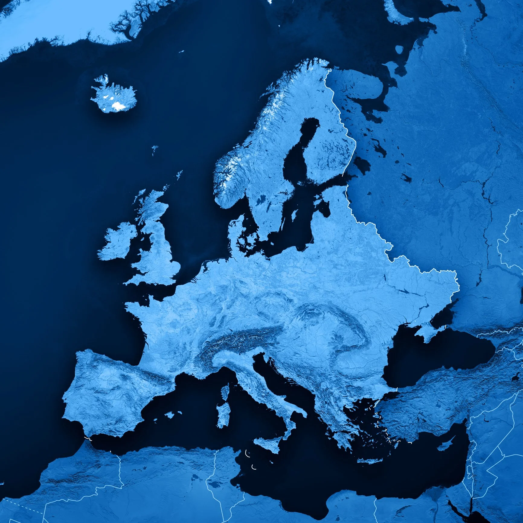
EUROPE
-
The Alps are the highest and most extensive mountain range in Europe, stretching approximately 1,200 km across seven Alpine countries: France, Switzerland, Italy, Liechtenstein, Austria, Germany, and Slovenia (from west to east). The alpine arc generally extends from Nice, France on the western Mediterranean to Trieste, Italy on the Adriatic; it is visible on the lower central portion of the map, just above the boot of Italy. The Pyrenees is the mountain range straddling the border of France and Spain in the lower left corner. It extends nearly 500 km from its union with the Cantabrian Mountains to Cap de Creus on the Mediterranean coast. The geography of Norway is dominated by vast mountain ranges broken up by sparsely populated valleys and some of the longest fjords on earth. The Lyngen Alps (the glaciated line of mountains on the uppermost portion of the map) are a mountain range in northeastern Troms og Finnmark, east of the city of Tromsø, in the arctic circle. Iceland (the large isolated island at the extreme upper left corner of the map) has similar Nordic qualities, but because of its unique geology (volcanic), is lower in elevation and lacks the steep topography found in both Norway and the alps. Click on image for Google Map.
Massif du Mont Blanc/Aosta Valley (France/Italy)
-
Topographic map of the central and eastern regions of the Mont Blanc Massif and the northwesternmost corner of the greater Valle d'Aosta region, including: Mont Blanc (far left); the north faces of the Aiguille du Midi leading into Chamonix valley (extreme NE corner of the map); Courmayeur du Mont Blanc where the south faces of Mont Blanc drain into Val Veny on the left and Val Ferret on the right (center left on the map); Courmayeur and Courmayeur valley (lower middle section of the map). The Aiguille Rouges, Glacier du Tour, and the Argentiere Basin are just out of view. (Image: Wikipedia. Click to enlarge).
Sella Ronda, Dolomites, Italy
Map: Sella Ronda MTB Tour
Vintage Piste Map: Courmayeur, Italy, “The Other Side” of Mont Blanc
Monte Rosa (Italy/Switzerland)
4 Vallees/Verbier (Switzerland)
St. Anton/Arlberg
Schladming-Dachstein
Karwendel Mittenwald Ski Resort
—————— SKI ROUTES INDEX ——————
EUROPE: The French Alps
EUROPE: Beyond the French Alps
Canada
Alaska
Colorado
The Tetons
United States: Other
South America/New Zealand/Japan
World's Best Ski Tours